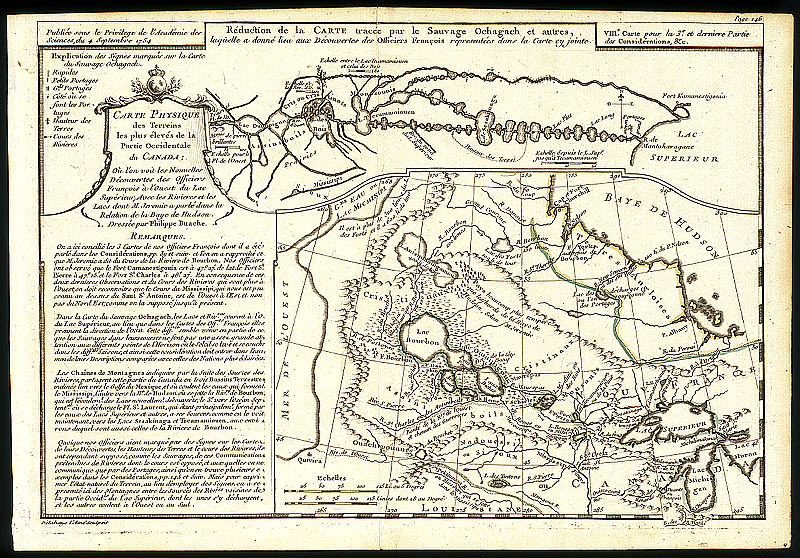
ARCHIVED - Western Canada, 1754, by Philippe Buache - The Canadian West - Exhibitions - Library and Archives Canada
 Library and Archive Canada - Bibliothèque et Archives Canada Français | Help     Canada  
  Important Notices | Proactive Disclosure  

Archived Content

This archived Web page remains online for reference, research or recordkeeping purposes. This page will not be altered or updated. Web pages that are archived on the Internet are not subject to the Government of Canada Web Standards. As per the Communications Policy of the Government of Canada, you can request alternate formats of this page on the Contact Us page.

 
The Canadian WestHome
AnticipationContactAccommodationIndexAboutNewSearchSite MapContact Us
Western Canada, 1754
Larger image Ref. No.: NMC-013295
< Larger Image >


Western Canada
1754, by Philippe Buache

Philippe Buache's 1754 map of the region west of Lake Superior attempts to show the two conflicting theories about the nature of the country that were prevalent at the time: the east-west flow of rivers mapped by the Cree Auchagah for La Vérendrye (top map) and the northwest-southeast flow (bottom map) reported by some French adventurers. Together, the two maps hint at some of the theoretical problems European map makers faced as they tried to unravel sight unseen the mysteries of Canada's western landscape.


Home | Index | About | New | Search | Site Map | Contact Us |  Français
Sections: Anticipation | Contact | Accommodation 
Materials: Reading List | Thematic Research Guides | Links | ArchiviaNet