Federal Administration
One of the first items of business undertaken
by the federal government after settling the Red
River Rebellion was the physical demarcation of
the international border with the United States,
which up to now had existed only on paper. Over
a three-year period (1872-1875), the International
Boundary Commission marked the 1,600 kilometres
of border stretching between Lake of the Woods
and the eastern slope of the Rocky Mountains.
For the first time, the international boundary
separated Canada's
Prairie West from its American counterpart.
The second administrative task that the government
set for itself was to establish some means of
policing and protecting
the border. Prime Minister John A. Macdonald
considered very carefully how such a police force
should be organized, and following the Cypress
Hills Massacre, put together the North-West
Mounted Police. It was unlike any other police
force in the world, with perhaps the exception
of the Royal Irish Constabulary. The North-West
Mounted Police retained a unique blend of
elements that were characteristic of both police
and military forces of the nineteenth century.
Its gruelling march
west along the international border in 1873
forever etched the police force in the Canadian
psyche.
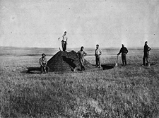
The third task was to begin a systematic inventory
of the region's natural resources. The Geological
Survey of Canada was given most of this responsibility
and, continuing in the tradition of Palliser and
Hind, proceeded to leave a legacy that went beyond
a mere inventory of rocks and strata. All aspects
of the environment
and its cultures became the Survey's laboratory.
The final task was to put together a survey program
which would see the region divided into the unique
checkerboard pattern of townships
that has become synonymous with prairie agriculture.
The survey system eventually covered 200 million
acres and was the world's largest survey grid
laid down under a single integrated system. It
led to the creation of more than 1.25 million
homesteads.
While undertaking these preparations, the government
found itself yet again fighting with the Métis
and First
Nations, but this time on the banks of the
South Saskatchewan
River at Batoche.
The event was closely monitored by easterners
through a budding media
industry. Once the North
West Rebellion was over, there was no clemency;
the leaders
of the rebellion were systematically rounded
up and imprisoned or executed.
Further
Readings
See also
The Canadian West: An Archival Odyssey through the Records of the Department of the Interior
The
Siftons
> Next Theme: Immigration
|